
As the last spasms of Tropical Storm Beryl head toward Vermont — a year after last summer’s devastating floods — meteorologists are increasingly confident that the incoming clouds will loosen a quick, heavy downpour on the state.
So quick, in fact, that the storm appears unlikely to result in the widespread flooding of last July, according to a forecast issued Tuesday morning by the National Weather Service. Rather, it is more likely to cause flash floods wherever rain is heaviest.
“Last year it was a marathon. This year it’s more of a sprint,” said Robert Haynes, a meteorologist at the Burlington branch of the National Weather Service.
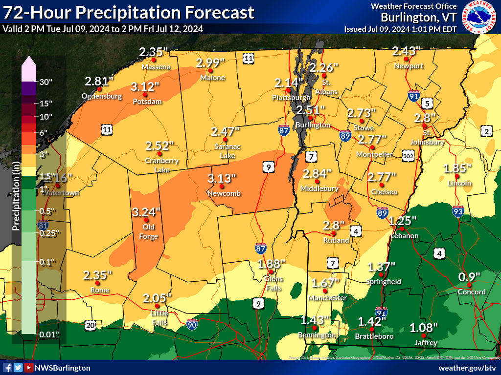
The bulk of the rain is expected to fall Wednesday afternoon and night, according to the forecast, with most of the state getting 1-3 inches. That’s a far cry from the 3-9 inches that fell over two days last July. The issue this time around, according to Haynes, is that the rain is likely to strike in a shorter, 6- to 12-hour window.
“We’re looking at less rain, but in a shorter time-frame,” Haynes said. “So, that would mean flash flooding in narrower regions, rather than statewide.”
There could, however, be parts of the state that receive 3-4 inches, and within those, “there could be a few spots that approach 5 inches,” according to the forecast. If those quantities materialize, the forecast warns about the possibility of “additional flooding across low-lying plains and roads,” on top of the flash flooding worries.
Though the when and how much of the storm are relatively clear at this point, pinpointing exactly where the heaviest rains will strike remains a challenge, according to Haynes. The major issue, he said, is the difference between the two types of prediction models the weather service uses for its forecasts.
The global-scale models, which cover the entirety of the planet, place the heaviest rains in the north of the state, along the Canadian border. But the larger scope of those models means they have lower resolution for specific regions, and as such they “can’t really resolve things like thunderstorms,” according to Haynes.
The high-resolution regional models differ widely, placing the heaviest rains in southern Vermont. But though these models “give you a better sense of the maximum precipitation amounts,” according to Haynes, they’re still quite iffy when it comes to accurately predicting location.
“Our current forecast is a blend between the two,” said Haynes.
Tim Humphrey, a meteorologist with the weather service’s Albany, New York office, which covers southern Vermont, said that until the storm came closer, the discrepancies between the models would persist.
“Once we get into that 24-hour time frame we should have much more certainty,” said Humphrey.
One thing the models do agree on is that the skies should clear up fast on Thursday, with dry air scattering the rain. But with the soil in central and northern Vermont having absorbed “150-200% above normal” rain levels in the past 40 days, runoff could make the rivers rise.
According to the forecast, “a reasonable worst case scenario would support the potential for minor flooding at the Mad River at Moretown, the Winooski River at Essex Junction, Otter Creek at Center Rutland and the East Branch Ausable River at Ausable Forks.”
Haynes recommended drivers avoid roads at risk of flooding, such as North Williston Road in Essex Junction and South Creek Road in Rutland.
Haynes put the chances of that worst-case scenario panning out at 10%.
Read the story on VTDigger here: Flash flood risk remains in Vermont, with heaviest rains expected Wednesday night.