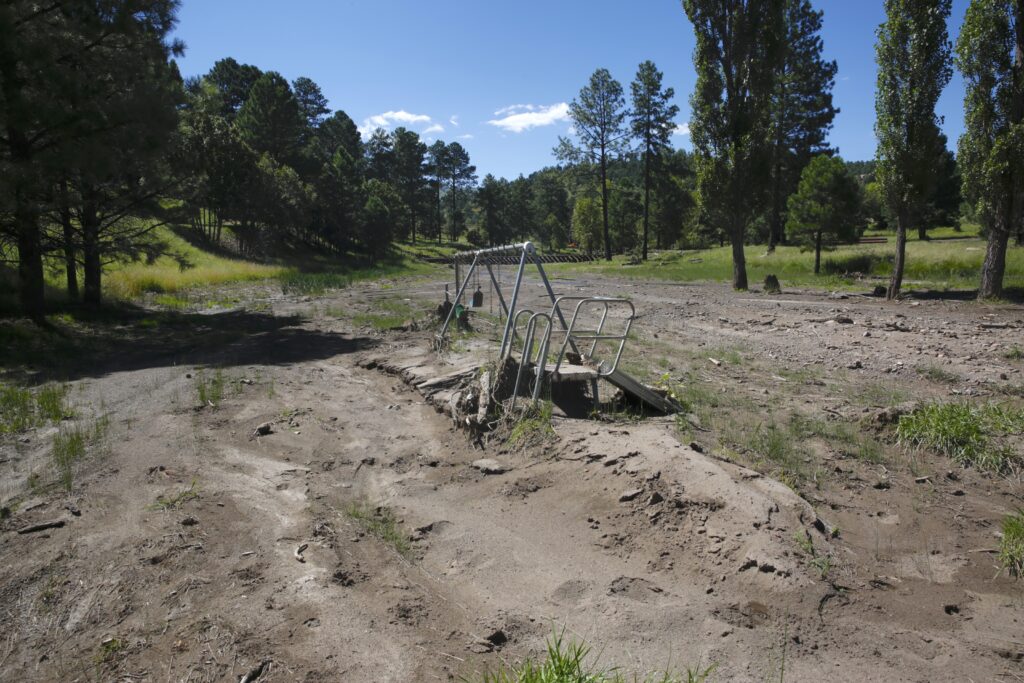
A playset partially submerged under soils near an arroyo in Ruidoso captured Aug. 20, 2024. Ephemeral streams and arroyos in the Hondo valley have been awash in debris flows from the heavy rains following the South Fork and Salt fires, carrying soils and ash down from the mountains into the valley. (Danielle Prokop / Source NM)
While monsoons returned to New Mexico this summer and alleviated some of the state’s acute drought concerns, areas hit by wildfire faced dangerous debris flows, and other places lost out on needed rain.
“Monsoons are a mixed blessing,” said Andrew Mangham, a hydrologist at the National Weather Service office in Albuquerque. “They are a very important part of our hydrology in the state, helping with our drought conditions and our crop conditions. But they come with some struggles, flooding in areas.”
New Mexico’s monsoons are always difficult to predict. This year, monsoon rains were pretty active across much of the state, including the Four Corners region and portions of Albuquerque. More rain meant severe flooding in the Hermit Peak/Calf Canyon and South Fork and Salt fire burn scars, which caused evacuations and damage.
One particularly fierce storm dropped five to six inches of rain in three hours, sending water and a slurry of soil and ash barreling down Highway 70. The debris, remnants of destruction from the South Fork and Salt fires, swept up trucks and dumpsters in a bout of flash flooding.
One of the fingerprints of climate change is the hotter air boosting storms, delivering high amounts of rain, said Mangham, a development that’s been visible in New Mexico the last 30 years.
“We’re seeing fewer storms, but when they do manifest, they’re much more intense, and that is exactly what you don’t want over burn scars,” he said.
On the other side of the mountains, in the area around Cloudcroft, rainfall accumulation is nine inches below its average, according to Anthony Brown, a meteorologist at the National Weather Service El Paso office in Santa Teresa.
Brown said this area has only received seven inches of rain since June.
More than 40% of the state was in extreme drought earlier this year, and after the rains, only 3% of the state remains in that dire condition. This includes portions of the bootheel and the southeastern plains in Otero and Eddy counties.
The most recent U.S. Drought Monitor Report for Sept. 10, 2024 shows reduced drought conditions across the state after summer rains alleviated some of the pressures. (Courtesy of U.S. Drought Monitor)
Much of the southern third of New Mexico remains in severe drought conditions, receiving less rain over the summer.
But while it didn’t rain, the moisture in the air trapped more heat, and raised the temperatures of the coldest parts of the mornings.
The summer in New Mexico may have felt cooler than last year’s string of triple-digit days and ‘nonsoon’ weather, but 2024’s nights were measurably hotter.
In fact, those sweltering nights bumped this summer to Las Cruces’ hottest on record, according to the National Weather Service.
Hotter nights pose health risks, exacerbating underlying heart conditions or diabetes, and worsen people’s sleep and keeps energy use up to use air conditioning at night.
“It compounds to the heat stress that people feel, because there’s just no relief at night,” Brown said.
Preventable heat injuries and deaths rising in New Mexico
Eyes will be on any drought areas, as forecasters expect a drier and warmer winter for New Mexico with a La Niña atmospheric pattern developing in the Pacific Ocean.
That atmospheric pattern can bring warmer temperatures, but also increases the risk of extreme cold, building a ridge of pressure that can push air from Northern Alaska and Sibera into the lower 48 states.
“The thing about La Nina is, even though, on average, our temperatures tend to be warmer than normal, we’re more likely to get cold snaps – those arctic air masses coming down,” Brown said.
But typically, the winters have less snow and rain. If the forecast holds true, drier landscapes and soils may grow thirstier over the fall and winter, Mangham said.
“Having a warm, dry winter sets the stage for a really problematic expansion of drought conditions in the spring,” Mangham said. “If we don’t get the good runoff through the area that doesn’t wet the soils, it doesn’t wet the fine fuels, it doesn’t recharge our aquifers and our reservoirs at all, then we’re in pretty rough shape when we get to our very dry spring season.”

