
You don’t have to convince Jeff Manville that the costs to upgrade infrastructure in Southbury was money well-spent.
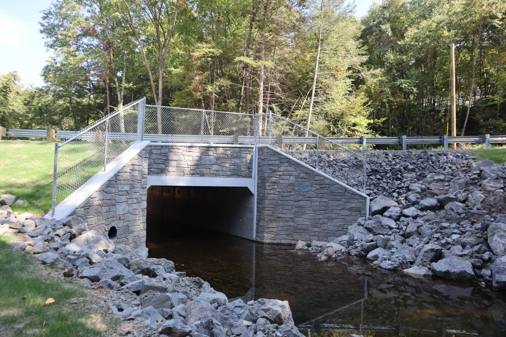
Manville — born and raised in Southbury, first selectman since 2015 — is happy to show off the evidence on a hot, blue-sky day precisely one month after catastrophic rain in the Naugatuck Valley area broke Connecticut’s all-time 24-hour rainfall record in less than 12 hours. The expensive bridges that in some places had replaced decades-old culverts show no evidence of the water that ran over them when the storm hit.
“They all held,” he said. “The flood water went over top of some of them, and when the water receded, everything was in place. Everything is OK.”
But the culverts that hadn’t been upgraded and the roads over them — not so much. They remain heaved apart, looking like an earthquake had struck.
Southbury’s damage estimate is a staggering $91 million and could be headed for $100 million depending on how much work the library, which sits in a dip in the landscape, will need. And that’s just municipal work — it doesn’t include private homes.
But without all the advance upgrades, “We would probably have been at least 20% more,” Manville said. “At least.”
Manville calls Southbury’s expensive preparation “generational equity” and “paying it forward.” Otherwise, he said, “aren’t we just kicking the can down the road to a more expensive repair? So to me, it’s let’s fix it right — now.”
Flooding has clearly become Connecticut’s biggest climate problem, with an increasing number of storms, as well as more extreme ones fueled by climate change. While the ferocity of the August storm is viewed as something of an outlier, the state has had catastrophic storms along with other sorts of severe weather each of the last several years, in some cases occurring over and over in the same locations.
The state’s emergency service’s director, Bill Turner, who in 2 1/2 years on the job has faced non-stop crises, most of it flooding, points out that every dollar that goes towards resilience saves multiple times that amount down the road. An ounce of prevention is worth a pound of cure, to channel Benjamin Franklin.
But a storm like the August one: “That was a 1,000 year flood,” he said. “A lot of our systems, they might be built to 100-year or 500-year flood standards. But this truly was a historic storm.” And he said more than 90% of the damage occurred outside what the Federal Emergency Management Agency, FEMA, designated as floodplain.
“What we need to do is — I don’t want to say take advantage of what just occurred, but use it as a lesson learned to show the importance of investing more in resilience and mitigation,” he said. “You hear the term a lot — build back better — and now is the time where things are destroyed to not just build them back to that pre-storm condition, but really focus on efforts that we can do to help them withstand the impacts of storms of the future.”
And that actually is happening at both the state and federal levels. Many initiatives were already in motion before the Aug. 18 storm hit.
Future-proofing
The Department of Energy and Environmental Protection on Wednesday unveiled the start of a process to revamp its Climate Resilience Fund. The fund was initiated just last year, doling out $8.8 million for planning and development, not construction, of some 21 flood prevention projects in 17 communities. The funding happened to include several drainage upgrades in the area hit by the August storm.
The point of the reboot is to give communities more tools and some of the money to help them do the kinds of advanced planning and construction that Southbury did on its own. DEEP Commissioner Katie Dykes calls it “future-proofing.”
“The thing that keeps me up at night is, how are we going to pay for all of this? How could we possibly pay for all this?” she said. “We’re talking about billions — billions — of dollars of investment. And so the answer is, we need to get as much federal funding into these projects as possible.”
DEEP’s main goal is to help communities unlock those federal funds. Generally, the funds from FEMA only cover 75% of these huge-ticket resilience projects. DEEP wants to set up a system for the state to pick up some of the remaining 25% based on a formula that would incentivize communities to put skin in the game, especially by embracing nature-based solutions, environmental justice considerations and by taking some responsibility for changes in their own municipalities.
DEEP will also supply the expertise many small towns don’t have, to figure out what to do and how to do it, by providing them with consultants to do the planning and design and grant writers to write the grants applications for them. They are also looking to set up a revolving loan system similar to the one that already exists for clean water projects.
The first step is a request for information to gauge interest, decide how to structure the program and come up with a clear formula for cities and towns. The deadline for that initial response is Nov. 8. State funds would be provided through bonds and would not require legislative approval.
“What hasn’t been there previously is a predictable framework that municipalities can count on to know that when they do the work to make this a priority, doing projects and raising revenue locally, that we’re setting aside funds to do resilience upgrades,” Dykes said. “And then hopefully the federal government will be there as a partner to get these projects done at the scale that this climate emergency requires.”
This all comes on the heels of several actions in the last year to deal with flooding. A new stormwater manual that DEEP unveiled late last year is just about fully in operation. It features stricter regulations designed to get more stormwater to soak into the ground rather than run off paved surfaces, leading to more flooding.
A new general stormwater permit known as MS4 is designed to force towns to get rid of some of their paved areas, known as impervious surfaces, every year.
And a resource from the National Oceanic and Atmospheric Administration that is used to predict precipitation amounts and location was updated to include conditions from climate change and released for public comment on Thursday as Atlas 15.
For the moment, in response to the recent storm, DEEP is providing an on-call contractor to help the affected communities access expertise and immediate repairs more efficiently.
As of now, President Joe Biden has declared a major disaster for Litchfield, New Haven and Fairfield Counties, opening up federal funding to affected individuals. The Small Business Administration will also make loans available to businesses and homeowners. Not yet determined is what FEMA will cover for the big state and municipal property repairs.
Assuming it will help cover costs, there will be new rules Connecticut will need to follow.
FEMA changes
New resiliency requirements for rebuilding damaged property when using FEMA funding went into effect Sept 9. That was after the flooding, but the trigger requiring their use happens when the emergency declaration was issued, and the first of those for Connecticut was last Friday.
Under the new requirements — known as the Federal Flood Risk Management Standard, FFRMS — more stringent construction standards may be mandated including higher elevations, locations for critical infrastructure, nature-based solutions and other mitigation strategies. FEMA notes that its “Mitigation Saves report found that adopting the latest flood resistant design building codes saves $11 per $1 invested.”
So while such practices may cost more initially, they should save money in the long run.
But somewhat out of sight, FEMA has already updated and continues to update information throughout New England so cities and towns can make more informed development decisions to keep infrastructure, buildings, homes and all other development out of harm’s way from flooding.
FEMA is responsible for mapping flood zones throughout the U.S. By statute, those maps are the basis for the National Flood Insurance Program, dictating which areas require flood insurance under certain conditions. The mapping has come in for some criticism that it is not up to date and relies on previous ground conditions, not what might happen in the future due to climate change and other factors.
Flood mapping generally takes years. In Connecticut, all coastal areas have been fully mapped.
“For the past half-dozen years, the focus has shifted to flood mapping inland riverine areas,” said Kerry Bogdan, the risk analysis branch chief at FEMA region one, which is New England. “The Quinnipiac watershed is complete, and all the others are in process.” Bogdan said the completion estimates for the rest range from winter 2025 to spring 2027.
FEMA’s riverine mapping update projects for Connecticut:
Farmington Watershed, Hartford County — projected effective date of Dec. 2025
Housatonic Watershed — projected effective date of fall 2027
Saugatuck Watershed — projected effective date of Nov. 2025
Shetucket and Thames Watersheds — projected effective date of Jan. 2027
Outlet CT Watershed — projected effective date of June 2027
In the wake of the August floods, Bogdan asked the U.S. Geological Survey to determine the high-water marks in the affected towns of Middlebury, Monroe, Naugatuck, Newtown, Oxford, Seymour, Southbury and Woodbury. The data will be used to help with accuracy of future mapping.
In the meantime, recognizing that climate change is something local officials are trying to incorporate into their planning, FEMA has developed products to help. Bogdan describes them as non-regulatory.
“They’re not going to tell you where you can develop, how to develop what your insurance rate should be, but they are going to convey that hazard risk,” she said. “What the risk is so people can plan for it.”
One tool developed specifically for region one looks at future coastal erosion hazards, taking sea level rise projections into account. It’s publicly available on a viewer,
“Homeowners can look at it. Business owners can look at it. Community officials who are making decisions about the resiliency of their community can look at it,” Bogdan said. “Some of our severely impacted communities from coastal erosion have really embraced this tool, and they’re incorporating it into their long term planning for things like grid retreat, placement of utilities, water lines, gas lines, that kind of stuff.”
Inland, Bogdan is just starting a pilot project in the Housatonic watershed to look at what increased rainfall, runoff, increased hydrology could do to future flooding. The plan is to create another non-regulatory tool for the inland areas that could communicate what future hazards look like with the goal of helping inland communities and people make risk-informed decisions.
Planning tools, risk assessments and flood maps aside, FEMA’s overarching message to people in New England has not changed: If it rains where you live, it can flood where you live. Even if it’s not technically a flood zone.
That message echoes the never-ending reminders from the Connecticut Insurance Department that homeowner’s insurance does not cover flooding, that you can get flood insurance if you don’t live in a flood zone, and that flooding — especially flash flooding like the state just had — can happen anywhere.
“We have to flip the conversation on this,” said George Bradner, director of the department’s property and casualty division. “Realtors have got to stop saying you’re not in a flood plain, you don’t need flood insurance. Banks have got to start looking at the flood exposure for that property and start requiring it on loans. People need to start being more in tune to what their risk is.”
If you ask Bradner, that means starting to require sellers of homes outside flood zones to disclose if the house has flooded. It means banks should look at the risk to homes near flood zones and maybe start to require flood insurance from more buyers.
He has also long advocated newer models such as community flood insurance, in which a city or town purchases flood insurance that individuals and businesses can buy into at more reasonable rates than they might otherwise find. There is also FEMA’s Community Rating System. By taking certain resilience actions, participating communities can lower flood insurance rates for residents. But documentation is cumbersome and labor-intensive, and only 19 Connecticut communities are currently participating. A couple were among those flooded in August.
The state Insurance Department also has just established a public-private council to look at ways to help homeowners and small businesses fund resilience upgrades to help lower their insurance risk.
In a coincidence of timing — also a month after the storm — the Connecticut Conference of Municipalities, CCM, released a report and recommendations on flooding in Connecticut.
The report, with the mouthful official name of “A Study on Understanding and Addressing the Occurrence of Local Flooding in Connecticut,” doesn’t really break new ground, pointing to funding and expertise as being key impediments to doing resilience projects. Most of the nearly three dozen recommendations have been offered previously. Some are already in motion. And CCM has been on record supporting state action to deal with flood prevention.
Responses to a municipal survey carried out by CCM.
But after two years and $100,000, the study wound up being released at a time of heightened concern about flooding, potentially providing a more interested audience for its messages.
“As bad as it is every time it rains, we get closer and closer to big action by municipalities,” said Graham Stevens, bureau chief for water protection and land reuse at DEEP. “The CCM report, yeah, they regurgitated everything that everyone already knew, but the fact that they did it and spent money on it is just unbelievable, really.”
“I think it speaks to this concern around preparing for climate resilience has really risen up the list for municipal leaders across the state because they’re on the front lines,” DEEP Commissioner Dykes said.
Among the recommendations are the insurance ideas that department has pushed for years and better flood mapping, which the state has very little leverage over.
But CCM has doubled back on the major resilience legislation it supported last session but that failed — SB-11. Among its many provisions, the bill would have authorized municipalities to establish resiliency districts to help generate funds for such projects. They would have operated similarly to stormwater authorities, which can generate money for those sorts of upgrades, though so far only two cities have opted to use them. The bill would have also upgraded building standards and allowed for zoning changes, both in the interest of more climate resiliency.
It’s going to take education and proof of how the money is being used, said Randy Collins, CCM’s associate director of public policy and advocacy.
“You want you tell residents we want to do these things, and we have to do these things, and this is what it’s going to be, and to allow them to see a visible result,” he said. “I think in the end most residents will understand, but they want to see a result. They don’t want it to say, ‘oh, it’s a property tax increase. Where does it go?’”
Other concerns
For Southbury First Selectman Manville, there are still plenty of worries, not unlike what he faced when a tornado struck his town in May 2018. That’s when he decided the town’s emergency service director needed to move to full-time status. That’s also when then town decided to map all the culverts and underground pipe to assess the drainage structure and begin a maintenance program that included clearing out all the overgrown detention basins.
But he said right now the town is very vulnerable because of a lot of culverts and crossings that are full or plugged.
“We have Band-Aided, but we’re still in a state of emergency,” he said. “Everybody thinks we’re not. We can go to Starbucks and get our coffee, and we can pretty much get around. But we’re very susceptible right now to a normal storm.”
He also points out that with both the tornado and August storm, only a tiny part of the state was affected. That meant nearly all state resources could be made available to help with cleanup and rebuilding. That is apparent for anyone just trying to get to Southbury. A month after the storm, the access roads, many still closed, sported armies of front-end loaders putting bridges, roadbeds and embankments back in place.
“If this was a weather event that affected the entire state of Connecticut, I would not have a gazillion loaders in town,” he said. “You could have people isolated for extended periods of time.”
“That is what worries me the most. A widespread hurricane, of a high magnitude … and then you’re not going to have the deep pockets that you have available right now, for Southbury, Oxford, Seymour. I mean, there’s people in other towns — they never knew this even happened.”
Related Stories:
CT officials say it will be ‘a long recovery’ from weekend flooding
For CT towns struggling to deal with flooding, help is on the way
As flooding worsens in CT, its drainage systems can’t keep up